Difficulté
Departure/arrival: former train station of Lamalou les Bains
This itinerary will take you to the heights of Lamalou-les-Bains, through vineyards and forest, passing through the village of Le Poujol-sur-Orb.
You will enjoy beautiful views over the Orb valley, before reaching the Croix de Baussels, the high point of the route. The return journey will take you through the hamlets of Fraisse and Villecelle before returning to the town centre of Lamalou-les-Bains. This route, which is not technically difficult, is ideal for a short outing with a limited difference in altitude.
RECOMMENDATIONS
BEFORE YOU LEAVE:
> Check the weather forecast.
> Find out about the state of the route.
> Inform someone close to you about your itinerary and the planned times.
> Take water and food.
ON THE ROUTES, PLEASE:
> Stay on the marked paths for your safety and to preserve the vegetation. Do not cut the laces.
> Respect the natural environment and the properties crossed; close the barriers.
> Respect the highway code, which applies to all sections of the route that use public roads.
> Don't litter and keep your rubbish with you.
MARKINGS:
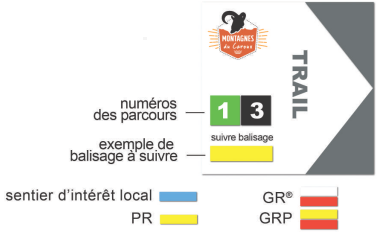
The courses are equipped with specific trail markers. Follow the course number indicated on the marker. Between two trail markers, follow the existing hiking markers:

RECOMMANDATIONS
AVANT DE PARTIR,
> Consulter les prévisions météo.
> Renseignez-vous sur l'état du parcours.
> Informer un proche de votre itinéraire et des horaires prévus.
> Prenez de l'eau et de quoi vous ravitailler.
SUR LES PARCOURS, MERCI DE :
> Rester sur les sentiers balisés pour votre sécurité et la préservation de la végéation. Ne pas couper les lacets.
> Respecter les milieux naturels et les propriétés traver-sées ; refermer les barrières.
> Respecter le code de la route auquel sont soumises toutes les portions de parcours empruntant la voie publique
> Conservez vos déchets avec vous.
BALISAGE :
Les parcours sont équipés de balisage spécifique trail. Suivez le numéro de votre parcours indiqué sur la balise. Entre deux balises trail, suivez le balisage randonnée existant : 


